28j56: River Hull, view south from the east
bank below North Bridge, 1981 - River Hull
Previous
Next
A view of Hull
28j56: River Hull, view south from the east
bank below North Bridge, 1981 - River Hull
Previous
Next
Still Occupied
Images on this site are arranged into rough areas by location as in my book 'Still Occupied', available on Blurb. Eventually this site will contain all the images in that book and more.
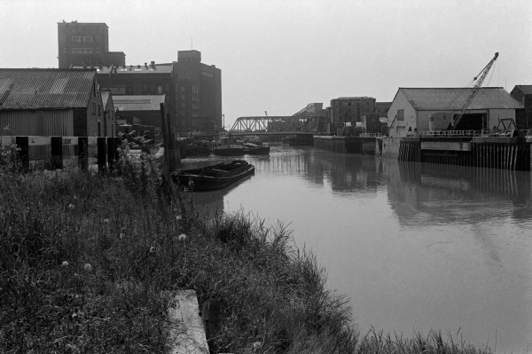
The path on the east side of the River Hull between North Bridge and Drypool Bridge was blocked in 1981, but limited access was possible. This picture was taken close to North Bridge looking south towards Drypool Bridge.
The Rank (later Rank Hovis) Clarence Flour Mill immediately left of the bridge opened in 1891, designed by one of Hull's best known architects, W. Alfred Gelder. Much of the mill was destroyed in heavy wartime bombing in 1940, when Hull was often used as a secondary target by any bombers who had failed to drop them in Leeds, Sheffield, Manchester, Liverpool etc, and was one of the most heavily bombed of all UK cities. When I was taking these pictures older Hull residents still complained that their city was never named in the wartime reports of bombing, just referred to, if at all, as "a north-east city."
The tall silo is mostly the original Victorian build but the mill was rebuilt and enlarged post-war. This former Hull landmark was demolished in 2016.
Obscuring much of the mill is another brick building which was probably a part of the Gamebore Cartridge Co. Ltd, whose Shotwell Tower at the left still produces the lead shot for use in their world-leading shotgun cartridges.
At the right of the picture are the gates of the Yorkshire Dry Dock, with a crane, and beyond them what remains of the entrance to Queen's Dock Basin which used to lead into Queens Dock, filled in as a rather dull and still part-sunken public park in 1930-34.
Peter Marshall
01784 456474